Quickly, we became familiar with the area because of the “road” signs present at wash intersections (they need the signs because there are zero, nil, zip, nada land marks out there…it’s a gigantic sand box). We easily made our way to the Shell Reef at Diablo Hill (not too hard to find a hill in a sandbox!). This hill is littered with fossilized shells, etc., and one can see the reef in the hillside cut. Impressive to even an engineer! Once satisfied I wouldn’t find an earth-shattering fossil of monumental scientific importance, we continued our never-ending quest to find the pumpkin patch.
I Wonder if He Knows the Way
After failed excursions up two washes, we made our way back to the main wash, where things became real interesting. Unfortunately, we didn’t load the USGS quad maps for the OWSVRA because we were limited on memory space. Even more unfortunate, we began to notice that the road signs were not right. Even more worrisome was the fact that several of the road signs had been knocked over, or people had twisted the sign such that we couldn’t tell which road went in which direction. Frustrated and a tad nervous, we decided to head due east to a row of power lines. We had a map showing this as
Back on asphalt (I’d have kissed the stuff if Analee would only stop), we went to the Old Stronitum Mine located near the mouth of Split Mountain Gorge. Heeding our mistake on the Calcite Mine, we took the camera up the long, winding trail to the mine entrance to find…nothing. The mine had long been closed, and all that remained were a few timbers used as rail supports. The most excitement was watching Analee speed past beehives that had taken up residence in old vein holes. Go Ana go! Although we didn’t find any Strontium, I did get a huge sheet of Gypsum that Analee warned would never survive the trip to NC…she was right. If you want a piece for yourself or for 200 of your closest friends, let me know.
Remnants of the Strontium Mine
After a peanut buttery lunch, and a fly over by the US Marines, we entered the Split Mountain Gorge. This area of the park is by far the most geologically active. The gorge is carved between 200-foot high canyon walls and littered with SUV sized boulders. Turns out these boulders fell from the canyon wall in a 1968 earthquake. As one could imagine, Analee was eager to leave the gorge. Although the chance of an earthquake and subsequently being squished by a boulder was probably 1,000,000,000 to 1, those odds were too likely for Analee. If she is a believer in those odds, she should start playing the lottery!
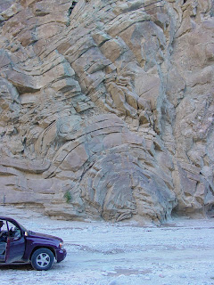
Anyways, we drove through the gorge and saw the world famous Anticline. For the layman, this is upwards folding of rock layers to form an “upside down horseshoe.” For an even simpler explanation, a lot of heat and pressure bent the rocks. Once through the gorge, we emerged in the Fish Creek wash at the foot of the Elephant Knees. The Elephant Knees is an eroded shoreline that looks like, well, you can figure it out. (Un)fortunately, this area of the park is closed for restoration so we couldn’t explore.
The Anticline in Perspective
From here we ventured about 12 miles back into, you guessed it, badlands! We will never learn. Apparently, the main wash (Fish Creek) has upwards of 20 more washes branching off. Lots of camel, horse and marine fossils can be found, but from the comfort and relative safety of the Trailblazer, we were essentially driving through more mud canyons. I was completely under whelmed by this leg of the journey, and was wishing we were relaxing in the hot pool instead of venturing so remotely that I’d probably have to eat my left hand to survive if we got stuck.
On cue, we finally began to meltdown (my word, we actually had a spat – our relationship is human!) about 14 miles into the trail at the head of
Elephant Knees
Back near the Gorge (and civilization), we stopped to do the
The Wind Caves
Once back through the Gorge, we turned down the “Road to
My brain hurts from writing. Ciao!


No comments:
Post a Comment